• There is NO official Otland's Discord server and NO official Otland's server list. The Otland's Staff does not manage any Discord server or server list. Moderators or administrator of any Discord server or server lists have NO connection to the Otland's Staff. Do not get scammed!

How big is too big? And how to solve the 'Archipelago' problem ALL maps have?

Sinth

Argardh.com
Joined
Jan 14, 2015
Messages
721
Reaction score
133
Location
Cambodia
Personally maps looking like archipelagos like Original Tibia isn't that appealing. Just a bunch of WoW-like instances(the latest 5 years of progress on the world-map at least).

But there's a reason for that isn't it? Most Custom maps looks the same even though some have put a lot of effort into starting with a big continent or re-doing the world-map as their maps have grown.

When does a map become too big? And what stops a server from having 10,000 players instead of 1000, technically?

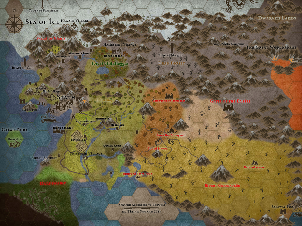
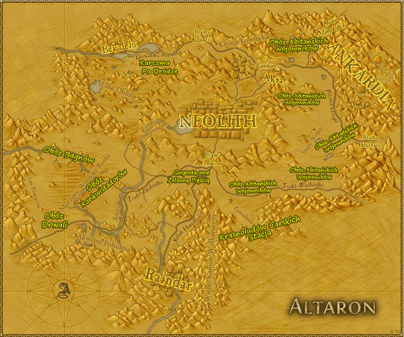
Anyone got some "World-maps" of their customs they want to show? For me mapping is 50% about landscaping.. i'll post mine later coming week when its borders are drawn..
 
Last edited:
What real map/piece of land/world have ever looked like this?? :p


vOLKp7i.jpg
 
It's a matter of necessary unrealisticness. You can't have the map stretch for thousands of thousands of tiles just to have the islands realistically separated from one another.
 
Well ofcourse but it has to remain realistic, in my opinion. Look at many mountains in Tibia they go from floor 7 to 0 in 2-3 tiles in many places(Kazordoon Area). Elsewhere aswell. Im a strong believer in landscaping..

But why not make "World-maps" with realistic distance then? And why not blow up a huge continent that is only sparely filled and then build from there? Archipelagos hurts the eyes, is unrealistic and creates rather boring gameplay with all boats, teleports, flying mats etc.. No?
 
SPCj51B.jpg


A small piece missing in the bottom. For reference size-wise you can find a re-modified Orc-fotress just north of the desert. The walls is barely visible. Rather big map so far and probably 90% self-made :)
 
How to better demonstrate the future designer of how the map should be drawn? :)
 
I agree with you, many people here are really good with details but quite frankly the maps feel too small. However you must understand that the main reason for that is that else it will take forever to map a server; even with borders what you showed on the pictures is merely the barebones of a map, right now it looks good but feels a little bland.

My advice would be that you somehow create a map you could block off certain areas while you are working them, like a mountain range or something, and let players have an actual impact on the map, by unlocking or working together to unlock the next area while improving the existing one.
 
You complain about the maps not looking correct, then you show us your creation.

You have ice north, separated by a single mountain range..
which leads to a grassland, which connects to a large swamp..
which is directly beside the sea.. and a desert separated by a thin mountain wall..
which also connects to the sea.. and is surrounded by yet more mountain.

As far as realism goes, you really can't complain about others work if yours doesn't actually follow real life examples either.
 
May a map like game of thrones with all types of lands, ice, sunny places, etc.

The archipelago problem that tibia has can only be solved by this i believe:

My advice would be that you somehow create a map you could block off certain areas while you are working them, like a mountain range or something
 
I agree with you, many people here are really good with details but quite frankly the maps feel too small. However you must understand that the main reason for that is that else it will take forever to map a server; even with borders what you showed on the pictures is merely the barebones of a map, right now it looks good but feels a little bland.

My advice would be that you somehow create a map you could block off certain areas while you are working them, like a mountain range or something, and let players have an actual impact on the map, by unlocking or working together to unlock the next area while improving the existing one.

Yeah that's what I've been trying to do instad of cutting it off with ocean.. feels and looks much better. Painted my map with a graphic-progrm, the mountains to the northeast, swamp to the south and "Empire" to the east is all to be "unlockable" by players in due time, some stuff already being done. I'm thinking it's a great way to make "instances" instead of using islands. The Dwarven lands for example is only reachable by underground train. Perhaps in a year though that entire mountain-range can be bordered and detailed :)


Btw, proud to be able to say: The real map looks impressively similiar :)

zjl5F5P.jpg
 
You complain about the maps not looking correct, then you show us your creation.

You have ice north, separated by a single mountain range..
which leads to a grassland, which connects to a large swamp..
which is directly beside the sea.. and a desert separated by a thin mountain wall..
which also connects to the sea.. and is surrounded by yet more mountain.

To be fair with the guy, I think mapping a transition between a desert and a grassland would be quite hard with the current sprites (new personal challenge, yay!), at least I haven't seen anyone do it, even CIP use mountains to separate them.

@Sinth The map itself looks good from afar, but remember people won't have such a view when playing, it will take you a lot of time to detail the map to a point where it's appealing for gamers, specially RPG gamers which seems to be the niche you're aming for; btw, what's the graphic program you're using? it looks neat!
I didn't say he did a bad job on his map, I was simply pursuing his statement that real tibia's archipelagos are unrealistic.
As far as cartography is concerned, both his and real tibia's maps are a joke.
However inside a fantasy genre we need to look past the small grievances and realise they are a necessity if we don't want to spend 15+ hours walking city to city.
 
To be fair with the guy, I think mapping a transition between a desert and a grassland would be quite hard with the current sprites (new personal challenge, yay!), at least I haven't seen anyone do it, even CIP use mountains to separate them.

@Sinth The map itself looks good from afar, but remember people won't have such a view when playing, it will take you a lot of time to detail the map to a point where it's appealing for gamers, specially RPG gamers which seems to be the niche you're aming for; btw, what's the graphic program you're using? it looks neat!

In the transition from grassland to desert I use dried grass, works like a charm :)

Well luckily for me i've already mapped 1000h so only got a few hundred more to go :p Inkarnate.com, HIGHLY recommended, you can do all kinds of awesome maps.
 
Last edited:
My suggestion is for people to stop using floor 7 as the main floor level. I suggest floor 4.
This will allow for greater visual floor variance generally and will also help create a natural flow to your mapping, for example when you're coming to a section of mountains, it will be desirable to create a valley system back down to floor 7 prior to reaching the mountains (to allow for the mountains to range from floor 7 to floor 0)

If I ever create another custom map, this will be one of the defining factors.
 
Last edited:
A
My suggestion is for people to stop using floor 7 as the main floor level. I suggest floor 4.
This will allow for greater visual floor variance generally and will also help create a natural flow to your mapping, for example when you're coming to a section of mountains, it will be desirable to create a valley system back down to floor 7 prior to reaching the mountains (to allow for the mountains to range from floor 7 to floor 10.

If I ever create another custom map, this will be one of the defining factors.

Thought the exact same way when this map was first forged :) From Tristrum to Crossroads Inn there's 1 lvl change and I think they are 3 and 4. For the desert however, I wanted plain plains.. :p

As far as cartography is concerned, both his and real tibia's maps are a joke.

https://en.wikipedia.org/wiki/Cartography

Saying my map is a joke "as far as cartography is concerned" is a joke. <-- Fact :) I'm not an educated cartographer but been making maps for 15 years + and studied geography on university level. You're allowed to have your opinion though :)
 
Last edited by a moderator:
My suggestion is for people to stop using floor 7 as the main floor level. I suggest floor 4.
This will allow for greater visual floor variance generally and will also help create a natural flow to your mapping, for example when you're coming to a section of mountains, it will be desirable to create a valley system back down to floor 7 prior to reaching the mountains (to allow for the mountains to range from floor 7 to floor 0)

If I ever create another custom map, this will be one of the defining factors.
would be pretty easy to make a specific city at floor 4 :p just shift drag on map editor and have it select lower floors too, move the whole city to floor 4 then you can do your nice chasms and ravines and nobody will be any the wiser ^^
 
Back
Top